Blunt Mountain
Introduction
The Blunt Mountain project is one of seven epithermal-porphyry projects on the Hazelton property, 45 km north of Smithers in British Columbia. Situated on the central north part of the Property (Figure 1) and spanning 70.62 km2, Blunt Mountain is a consolidated project area comprised of twelve claims.
After reviewing historical prospecting, staking, geological, geophysical and geochemical exploration data and completing a small-scale surficial sampling program in 2017 and 2018, the Company remodeled a selection of historical results and identified the outlines of a potentially large and deep-seated Cu-Mo porphyry system indicated by a significant magnetic anomaly. Based on those modeling results, the project area was expanded, consolidated and defined as a target. Blunt Mountain is located at the centre of the Skeena Arch Bulkley intrusions. The Company is studying the extent of impacts from Laramide events on porphyry generation in the area (Figure 2).
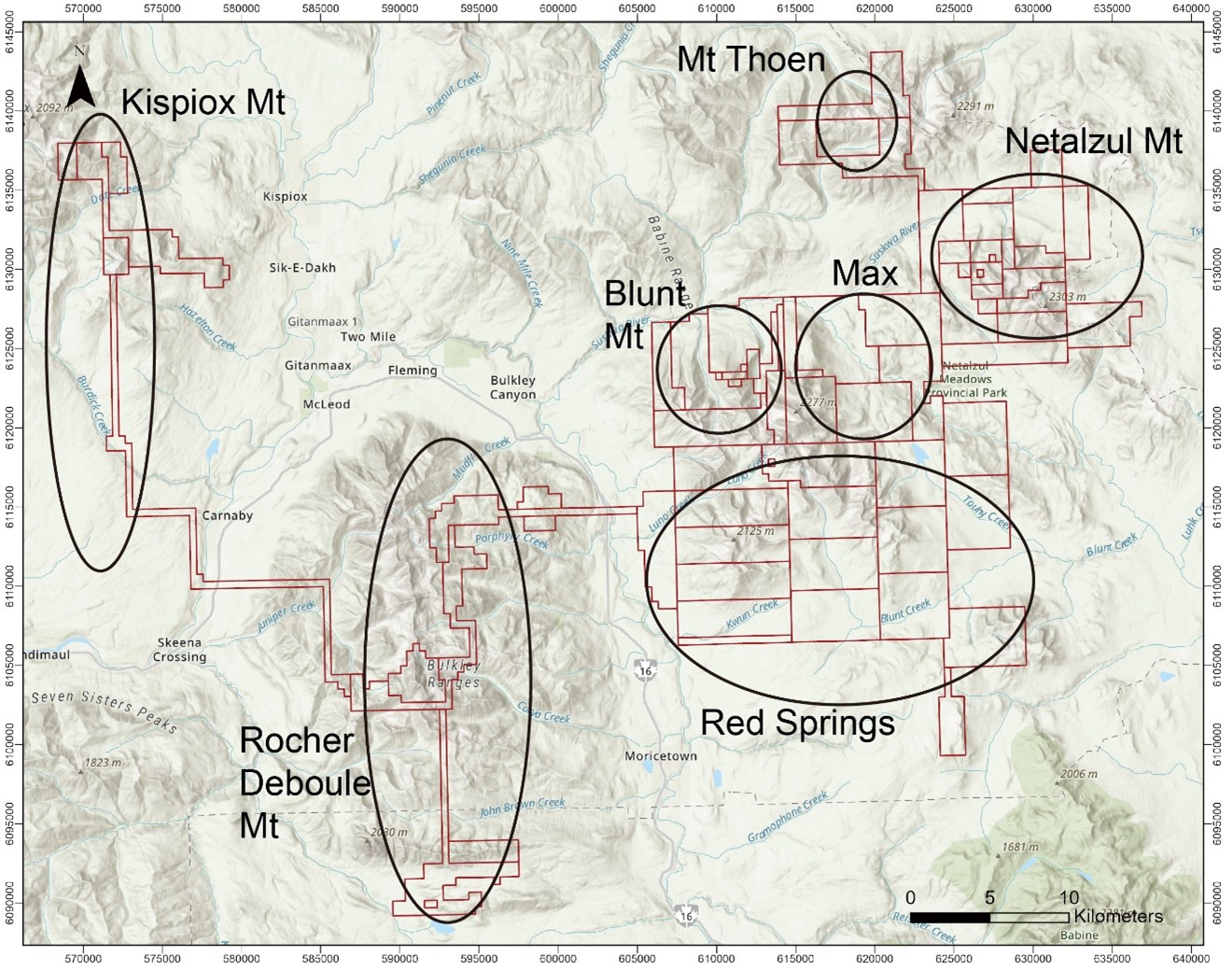
Figure 1. Map of claims and seven projects on Jaxon's Hazelton property.
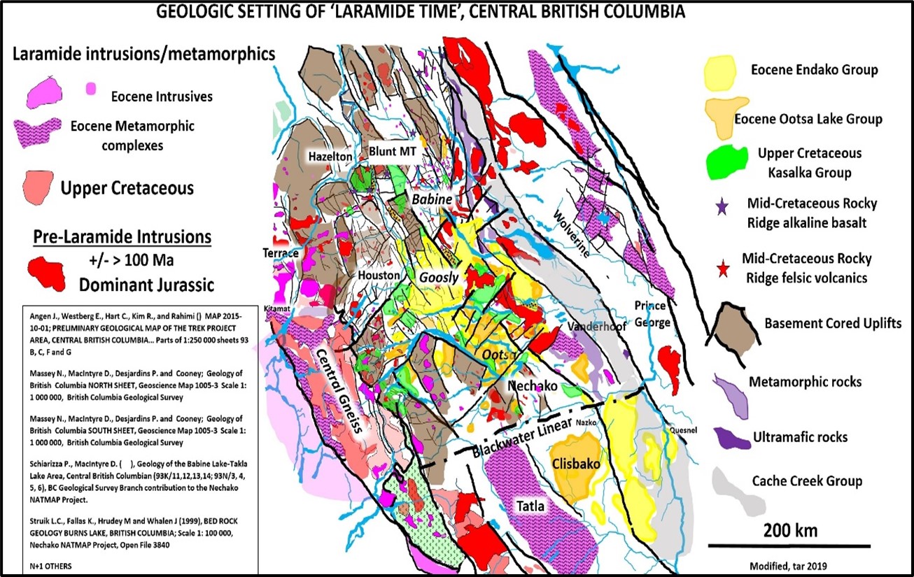
Figure 2. Geologic setting of "Laramide Time", central BC (Tom Richards, 2020)
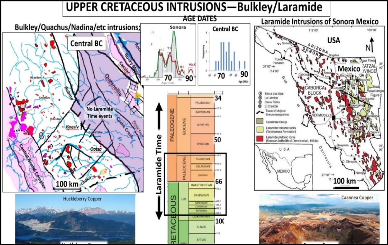
Figure 3. Upper Cretaceous Instrusions-Bulkley/Laramide comparison (Tom Richards, 2020)
Exploration History
A geochemical survey conducted by the provincial government in 1984 indicated a stream sediment sample from Skilokis Creek with anomalous silver, lead, arsenic and antimony values of Ag 3.6 ppm, Pb 85 ppm, As 225 ppm and Sb 7ppm. The general source area was staked by Atna Resources Ltd. (Atna) and Noranda Exploration (Noranda) in 1984 and 1985.
Subsequent work included 105 soil samples, 55 rock samples, 20 silt samples and two stream sediments. In 1985, both companies located mineralization in a tributary (Clay Creek) of Skilokis Creek and in a cirque to the northwest, the headwaters of Ferri Creek. A 50-50 joint venture agreement between Atna and Noranda was signed in late 1985 and limited exploration carried out. The results involved discoveries of five sulfide mineralized zones, Pat, H, B, C and D, with rock samples values as high as 26.5 g/t Au, 13% As and 1400 g/t Ag. The mineralization was found to occur in quartz veins or altered granodiorites (Figure 4).

Figure 4. Map of five historical showings and geology of Blunt Mountain mineralization area (based on data from Atna and Noranda, 1984 and 1985)
In 1986 and 1987, Noranda completed an extensive program including prospecting, soil, silt and rock geochemistry, geological mapping, ground magnetic and VLF-EM surveys, hand trenching and diamond drilling (six holes totaling 378 m).
Highlights and comments from the program:
- Six holes totaling 378 m were drilled to test showings but due to technical issues, recoveries were low. One sludge sample from 87-03 at a depth of 20 m within a structured weathering zone returned 0.38 g/t Au and 84 g/t Ag over 1.25 m. In 2021, Jaxon’s geologists examined the drill sites at Blunt Mountain and observed that the drill holes were drilled to the southeast (azimuth 60° to 110°-120°) from -45° to -54°. However, the mineralized zone strikes ~40° NE and dips SE ~40° to 60°. It was observed that the historical holes were drilled parallel to the mineralization zone and into the footwall rock below the mineralization zone (Figures 5, 7).
- Abundant mineralized float found on surface. The best float sample 86820 returned 2.33 g/t Au and 585 g/t Ag.
- Two rock types encountered in the drill hole: 1) feldspar porphyry and 2) monzonite, diorite.
- The gold mineralization zones in BM86-1 may represent a distal sulfide vein type gold mineralization within the magnetic low area based on the preliminary magnetic and soil sampling program (Figure 6). The future drill program should be targeted to the transition area between magnetic high and magnetic low areas.
The Blunt Mountain Project is underlain by clastic sediments of the Jurassic Bowser Lake Group which are intruded and hornfelsed by a monzonitic to dioritic pluton of the Late Cretaceous Bulkley intrusive which is cut by granite of unknown age and by intermediate, feldspar porphyry dykes. Several types of alteration and mineralization have been discovered on the property. The most important type is Ag-Au-Pb-Sb-Zn-Cu mineralized quartz veins.
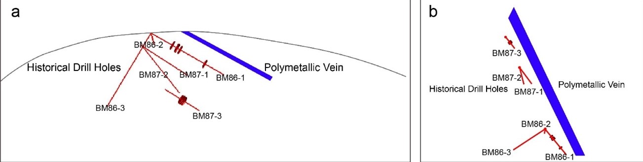
Figure 5. Section map of drill holes at the Blunt Mountain project.

Figure 6. Outline mineralization and geology map of the Blunt Mountain project (1986 Assessment Report).
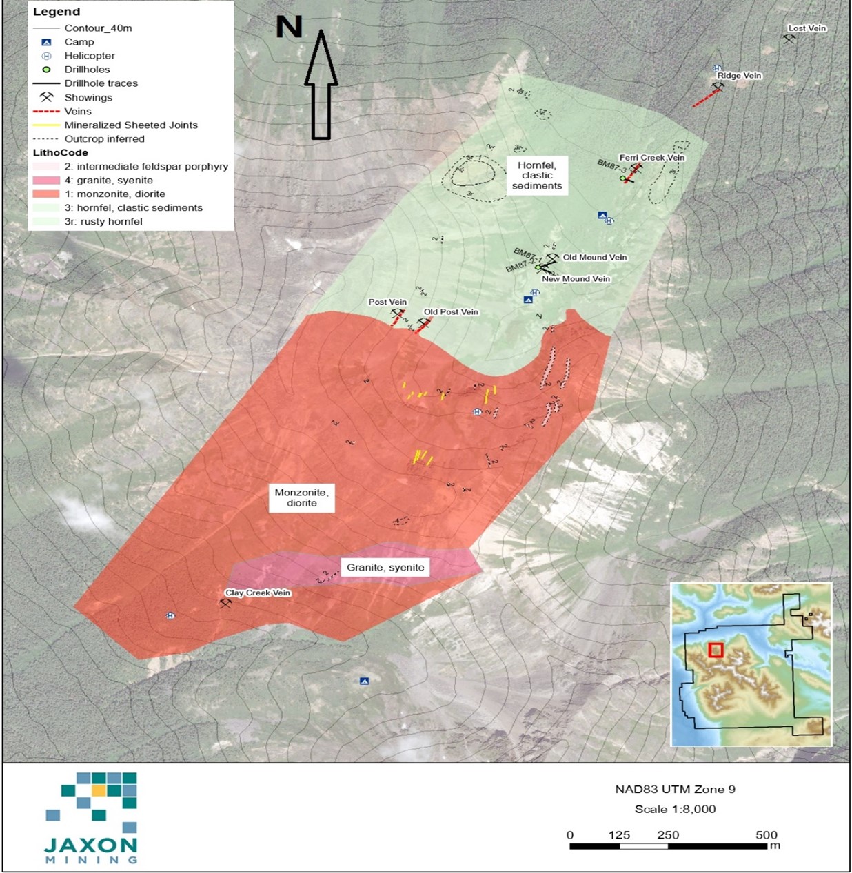
Figure 7. 1987 drill hole locations and simplified geology map of the Blunt Mountain project (based on 1987 assessment report).
In 1990, a brief site visit was made and nine rock geochemical samples were collected for analyses.
In 2005, G.E. Nicholson made a one day visit to the property to determine the access and logistics, conduct a general view of the geology and to make recommendations for future work.
In 2006, prospectors L. Stephenson, M. Nelson and Richard Simpson spent three days on the property and collected 52 rock samples on six traverses. 36 of the samples were from outcrop and 16 floats. All samples were analyzed by ALS Chemex of Vancouver and six samples were submitted to Vancouver GeoTech Labs for petrological descriptions.
Results in 2006 indicate that the galena vein, known as the Mound Vein, contains a significant quantity of Au and Ag along with Pb, Cu and Zn. Results from analyses of samples collected over the four traverses indicate that precious metals have ranges from 10 ppb to 1,500 ppb Au and from 0.05 ppm to 5,410 ppm Ag. The deposit is a polymetallic, Pb +/- Cu +/- Mo +/- Zn +/- Au +/- Ag, vein system that may be related to a porphyry system in the area.
In September 2014, a surficial exploration program was completed on the Mineral Hill Property (Figure 8). The program focused on prospecting and sampling the ridge south of the old camp, prospecting and sampling the cirque around the old camp and limited sampling of core stored at the old camp site.
The 2014 surface program focused on taking rock samples from sites containing visible sulphides, quartz veining and limited sampling of historic diamond drill core. Rock sampling confirmed historic results of anomalous lead and zinc values which may be indicative of a hidden porphyry system on the property.
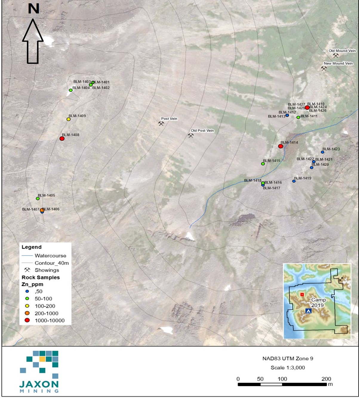
Figure 8. Location map of rock samples from the 2014 program.
Geology of Blunt Mountain Project
Blunt Mountain lies within the Intermontane Belt of British Columbia. The Skeena Arch, a broad structural high trending north easterly, underlies the area.
Sedimentary rocks of the Middle Jurassic to Late Cretaceous Bowser Lake Group and Kasalka Group underlie the Project. Late Cretaceous Bulkley intrusives intrude this group. A brief summary of the two groups, taken from Maclntyre et al. (1994), is given below (Figure 9).
- Undivided Bowser Lake Group (mJKBo) - interbedded epiclastic feldspathic wacke and volcanic conglomerate, sandstone, siltstone, mudstone, shale and argillite; minor coal and carbonaceous units; minor basalt and andesite flow, breccia and tuff, dacite lava, lapilli tuff (Maclntyre et al., 1994; Geoscience BC, 2010).
- Kasalka Group (uKks) unnamed equivalents-hornblende- feldspar porphyritic andesite to basalt flows and related pyroclastics, breccias and epiclastic beds, lesser dacite, rhyodacite, basaltic andesite, quartz porphyry; sandstone, conglomerate (Geoscience BC, 2010).
- Bulkley Intrusions (LKg) - biotite-hornblende granodiorite to quartz diorite, diorite, quartz monzonite, rhyolite and quartz-feldspar porphyry, biotite-hornblende feldspar porphyry, biotite-feldspar porphyry, hornblende-feldspar porphyry; minor andesite felsites, aplite, alaskite and intrusive breccia; stocks, plugs sills and dykes; 64 to 84 Ma (Maclntyre et al., 1994; Geoscience BC, 2010).

Figure 9. Simplified geology map of Blunt Mountain project (Geoscience BC, 2010).
The sedimentary rock adjacent the intrusive contact has been converted to hornfels. North trending feldspar porphyry and quartz feldspar porphyry dykes transect the area. The polymetallic mineral showings occur mostly in the hornfels along a north-easterly trending structure which transects both rock types. The Cu-Mo porphyry mineralization showings exist in the nearby Bulkley intrusives in the project area also. Two types of mineralization, such as copper-molybdenum porphyries and silver-gold-lead-zinc veins have been discovered at the Blunt Mountain Project.
Magnetic Features
In 2010, Geoscience BC completed the Quest-West Project, a 1:500,000 aeromagnetic survey program conducted in central west B.C., which includes Jaxon’s Hazelton property area (Figure 10).
There is a strong positive magnetic anomaly area in the north-west part of the Red Springs Project and south-east part of the Blunt Mt Project. The historical mineralization showings and workings were focused on the medium and low positive magnetic anomaly area at Blunt Mountain, which is similar to Red Springs, south of Blunt Mountain and the Netalzul Mountain Project in the north-east corner of the Hazelton property.
The Company notes that to date, there have been no historical mineral showings or MINFILEs recorded at the magnetic high area.
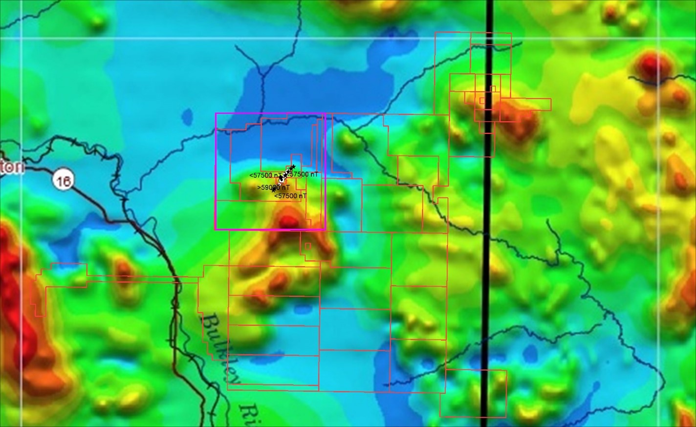
Figure 10. RTP magnetic anomalies map of Hazelton property area (Quest-West Project, Geoscience BC, 2010).
A detailed aeromagnetic survey was conducted in the historical showings area of the Blunt Mountain Project in 1986 by Noranda and Atna (Figure 11). It generally coincided with large regional magnetic survey results. The historical drilling was focused on the magnetic low area at Blunt Mountain.
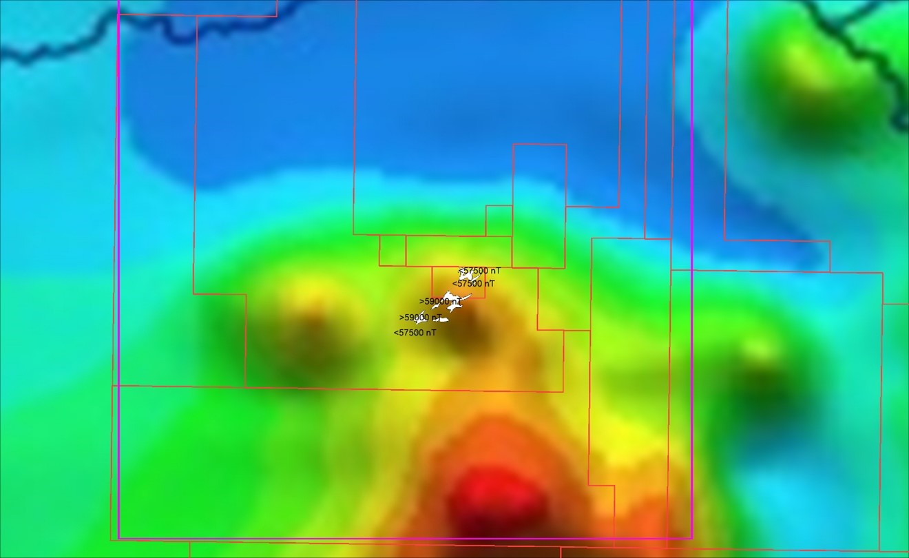
Figure 11. Detailed local and regional magnetic anomalies map of a section of the Blunt Mountain project.
Mineralization
Mineralization in the region consists most commonly of copper-molybdenum porphyries and fracture controlled epithermal sulfide mineralization veins. The veins are silver, gold, antimony, lead and zinc bearing and are the distal sulfides mineralization related to the deeper Cu-Mo porphyries in the Bulkley intrusion.
Historical assay results indicate a mineralization corridor along or near the contact zone between the granodiorite intrusive and hornfels sedimentary rock with up to 29.34 g/t Au, 5410 g/t Ag, 4478 ppm Cu, 4000 ppm Mo, 10% Pb, 8.2% Zn and 3.8% Sb (Table 1 and Figure 12).
A total of thirteen showings were identified from previous exploration. The showings are either copper-molybdenum porphyries or Ag-Au-Pb-Zn-Sb veins related to various Late Cretaceous Bulkley intrusive, forming a north-easterly trending mineralization corridor approximately 4 km long and 150 metres wide (Figure 12). Within the corridor, veins are occasionally exposed on surface, forming a continuous line or an en-echelon system. Veins dip steeply and several veins are exposed by historical trenching over tens of metres. The mineralization is associated with concentrations of galena, sphalerite, pyrite, arsenopyrite and stibnite in quartz and tourmaline veins and associated silicification. Adjacent rocks are altered intrusive or hornfels sedimentary rock.
Table 1. Polymetallic element assay results from historical assessment reports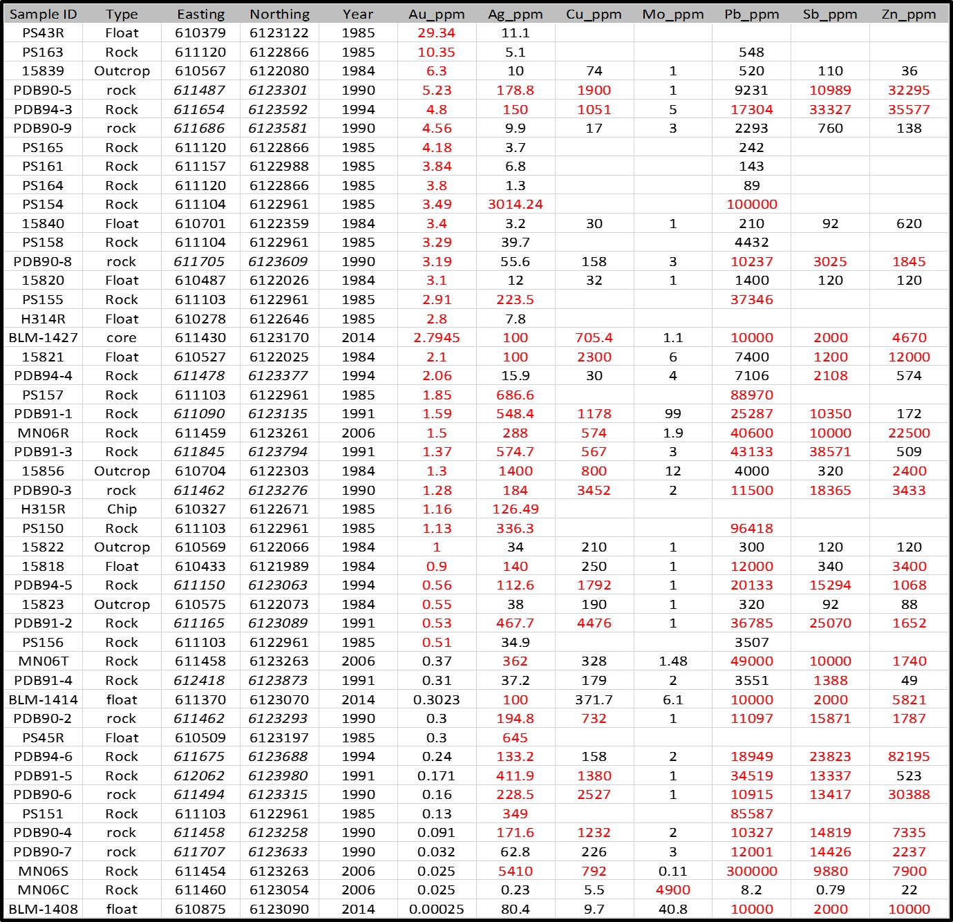
Best chip sample results to date report 4.05 g/t Au over 1.2 m from the Ridge Vein and 5.62 g/t Au over 1.6 m from the Old Post Vein. Gold is found from 0.2 to 9.05 g/t and silver from 2.68 g/t to 1400 g/t in showings over varying thicknesses of 0.3-1.2 m. Six drill holes totalling 378 m tested showings. Due to technical drilling problems, recoveries were generally low.
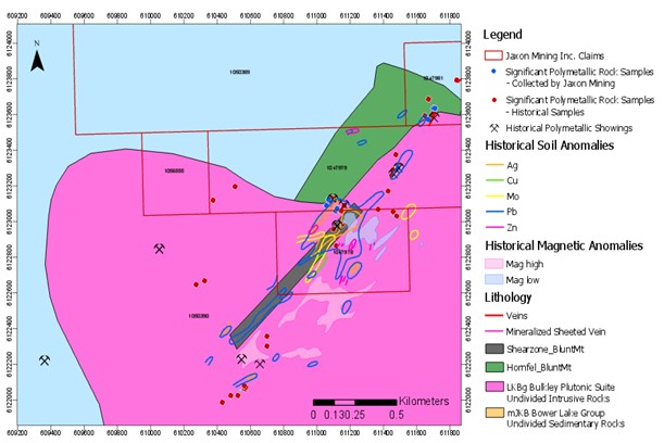
Figure 12. Outline map of geology, mineralization and historical showings at Blunt Mountain project.
Jaxon conducted a field prospecting program in the 2017 and 2018 field seasons collecting 19 outcrop chip and grab samples (Figure 12 and Table 2).
The granodiorite intrusive is cut by a well-developed set of sheeted joints at an approximate 40o strike and is mineralized with amphibole-quartz-magnetite-apatite-sulfide vein. The veins can be zoned and laterally change to predominantly quartz-arsenopyrite-tourmaline vein.
Assay results from outcrop grab and chip samples taken during the 2017 and 2018 field seasons report up to 1886 g/t Ag, 5.45 g/t Au, 2413 ppm Cu, 217ppm Mo, >1% Pb, >1% Zn and >1% Sb (Table 2). These results confirm the historical assay and existence of a distal Au-Ag-Pb-Zn-Sb sulfide vein mineralization. The historical air magnetic anomalies outline the transition zone between the magnetic high to magnetic low, along the contact zone of Bowser Lake sedimentary rocks and Bulkley Creek intrusive. The developed quartz vein type polymetallic mineralization is overprinted near the contact intrusive and sedimentary rocks, interpreted as potential to host a hidden porphyry type Cu-Mo-Au-Ag mineralization along the magnetic transition belt.
Table 2. Significant assay results and samples details from the Blunt Mountain Project
Jaxon conducted a field prospecting program in the 2021 field seasons collecting 14 outcrop chip and grab samples and 99 soil samples (Table 3). Seven of the chip/grab samples averaged 1079 g/t AgEq. The epithermal silver polymetallic quartz vein/breccia mineralization zone is observed to be up to 2 km long and 1 m to 5 m wide.
Key Highlights of the 2021 Rock and Soil Sampling Program
Sampling identified a large, high-grade, epithermal silver polymetallic mineralization zone. One grab sample from an outcrop in the mineralized zone reported up to 1795 g/t AgEq (silver equivalent) including 923 g/t Ag, 2.68 g/t Au, 4.04% Sb, 8.39% Pb, 2.09% Zn and 0.36% Cu (Figure 13, Sample 072030). Two channel chip samples (072046 and 072047) approximately 2.5 m wide reported up to 878 g/t AgEq including 504 g/t Ag, 0.66 g/t Au, 2.98% Sb, 0.73% Pb, 1.41% Zn and 0.16% Cu (Figure 14); seven samples were taken from the south (072045), centre (072028, 072030, 072046, 072047) and north areas (072029, 072050) along strike in the mineralization zone, indicating the existence of near-surface Ag-Sb rich polymetallic epithermal mineralization. The strike extends approximately 2 km along the surface (Figure 15 and Table 3).
- 99 soil samples were collected along the mineralization strike and tested with a handheld XRF analyzer. Ag, Cu, Pb, Zn, Sb and As were detected and all show the same pattern of strong chemistry in soil anomalies along the mineralized zone confirming the continuation of this Ag-Sb rich polymetallic epithermal mineralization along strike (Figure 16).
- Field observations confirm the mineralization strike to be approximately NE40o, dipping SE at angles of 40o to 60o. Noranda drilled the area in the 1980s but missed the mineralization. Their holes were drilled parallel to the mineralization or were not deep enough to hit the target (Figure 5).
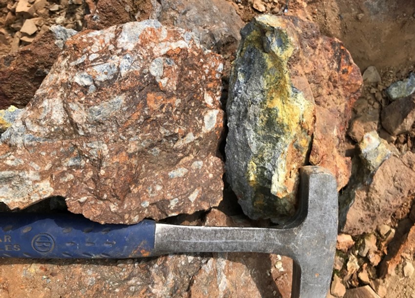
Figure 13. Grab sample 72030 assayed 923 g/t Ag, 2.68 g/t Au, 4.04% Sb, 8.39% Pb, 2.09% Zn and 0.36% Cu at the central part of the mineralization zone.
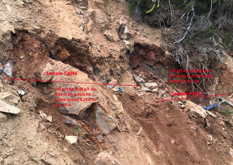
Figure 14. Chip-channel samples 72046-72047 at the central part of the mineralization zone.
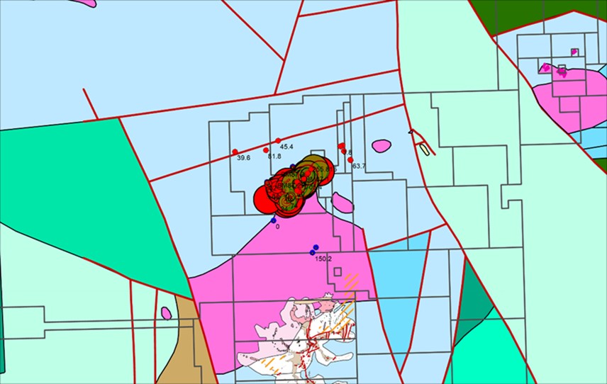
Figure 15. High-grade Ag-Sb rock samples along the mineralization zone (Ag represented by red dots; Sb represented by yellow
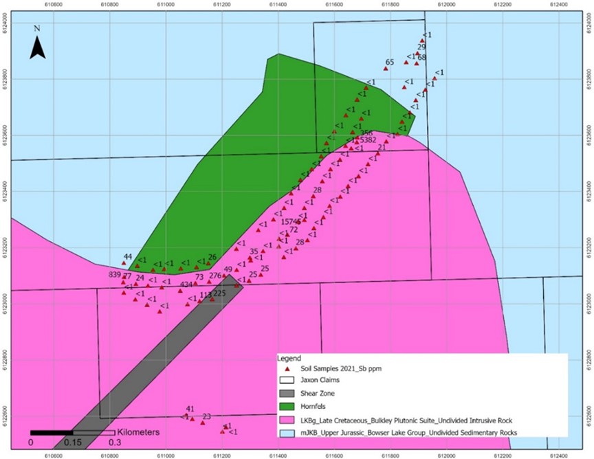
Figure 16. Sb in soil anomaly using XRF analyzer.
Table 3. Significant Assay Results from Rock Samples at the Blunt Mountain Project*
| Sample ID | Description | Ag ppm | Au ppm | Sb ppm | Pb ppm | Zn ppm | Cu ppm | EqAg |
|---|---|---|---|---|---|---|---|---|
| 72027 | 4 meters wide quartz tourmaline breccia zone | 4 | 0.663 | 32 | 557 | 46 | 17 | 53.58 |
| 72028 | 1-5 m massive sulfide galena, arsenopyrite and stibnite, str. chlorite and sericite alteration NE35 degree striking, dip to SW at angle 45 | 335 | 1.273 | 39140 | 93500 | 42100 | 1720 | 1182.84 |
| 72029 | 778 | 1.21 | 49860 | 110700 | 5091 | 1032 | 1602.49 | |
| 72030 | 923 | 2.68 | 40430 | 83900 | 20900 | 3587 | 1795.96 | |
| 72045 | 92.1 | 3.055 | 17430 | 52000 | 472 | 218 | 609.08 | |
| 72046 | 1.5m wide channel sample with arsenopyrite, galena and stibnite | 762 | 0.377 | 48860 | 10080 | 19600 | 2479 | 1300.79 |
| 72047 | 1m channel sample, transition zone between sulfide zone and intermediate dyke, possible dacite | 117 | 1.087 | 1268 | 3122 | 5907 | 340 | 243.77 |
| 72048 | dacite dyke | 1.6 | 0.005 | 46 | 57 | 2864 | 49 | 10.16 |
| 72049 | chlorite fine grain hanging wall, hornfels | 8.2 | 0.005 | 202 | 5363 | 1287 | 81 | 26.59 |
| 72050 | 80 cm, mainly arsenopyrite and stibnite, striking 30 NE dip at 70-80 degree | 253 | 1.061 | 48630 | 11770 | 18800 | 400 | 821.46 |
*Silver equivalent (AgEq) grades are calculated in USD based on the following: Au @ $1800/oz, Ag @ $24/oz, Cu @ $8000/t, Zn @ $3000/t, Pb @ $2200/t and Sb @ $6000/t.
Conclusions and Work Plan
A 4 km-long and 1 km-wide vein system represents the surface expression of a large intrusion driven epithermal system. Numerous feldspar porphyry dykes are found on the property close to the epithermal vein mineralization. Feldspar porphyries are found in the nearby Red Springs project and may be related to each other.
The 2021 surface program focused on collecting rock and soil samples along a northeast-trending quartz-sulfides vein. The quartz-sulfide vein is observed along sheeted fracture and shear zones, which are adjacent to the contact zone between the Bulkley intrusions and sedimentary rock of Bowser Lake Group. Both rock and soil samples return good silver, antimony, lead, zinc and copper anomalies. The high-grade polymetallic vein is associated with Bulkley intrusion and indicates a hidden porphyry system on the Blunt Mountain property.
These sampling results place the Blunt Mountain porphyry-epithermal system target third out of seven in Jaxon’s ranking of targets. The pervasive nature of mineralization at Blunt Mountain is typical of the mineralization distribution found in epithermal caps above major porphyry systems. The geochemical data resulting from the 2021 sampling program will be utilized to inform further geological modeling exercises. The data will be augmented by the results from additional geochemical and geophysical surveys. These surveys and additional work on Blunt Mountain will be conducted after a drill test of the Netalzul Mt porphyry system has been completed.
Jaxon is planning a comprehensive study, including geological mapping, rock sampling, soil sampling along the strike, and re-logging of historical drill holes. The geological mapping and rock sampling will further define the known mineralization veins extension, identify new veins, and define areas for additional exploration. An IP survey and ground magnetics will also be conducted to locate the deeper porphyry system generating the near surface mineralization.
The 4 km long and up to 150 m wide vein system is believed to represent a surface expression generated by a large porphyry intrusive system. Numerous feldspar porphyry dykes were discovered in close proximity to the sulfidation vein mineralization and to the distal large propylitic alteration halo in the east part of the area (Figure 17), extending to the east section of the Red Springs porphyry system. The porphyries at Blunt Mountain could potentially be part of the same system and may be related to the same ore-forming processes. This possibility will be examined in the course of future exploration.
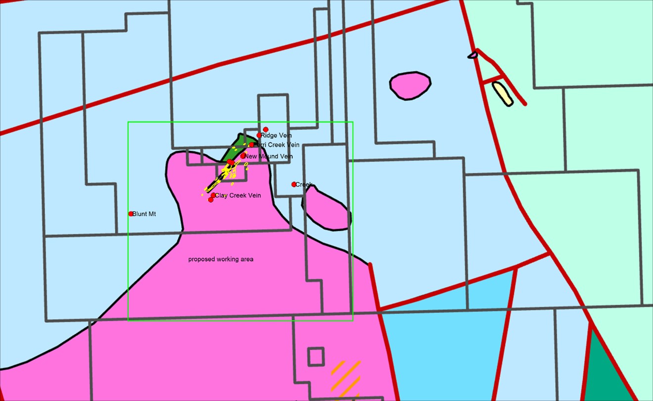
Figure 17. Geology and MINFILE map and proposed work area at Blunt Mountain project.
Future Exploration Work
- Comprehensive geological mapping and a rock sampling exercise using the locations of the known showings and collars from the historic diamond drill holes. Expand the mapping to cover the unexplored top part of Blunt Mountain where the Bulkley intrusive is prevalent. Geological mapping and rock sampling programs will follow the known veins and structures, identify new veins and define new areas for additional exploration (Figure 17); special focus on both ends of the extension of the main high-grade mineralization zone along strike and newly discovered 4 metre-wide quartz tourmaline breccia zone (Sample # 72027 at UTM E611202 and N6122543) (Figure 18).
- The Creek showing (MINFILE 093M140), approximately 2 km south-east of the main showing, is a molybdenite occurrence hosted in a contact zone between Bulkley intrusion and Late Cretaceous hornfels on the west side of Blunt Mountain. Geological mapping and rock sampling are planned for this area (Figure 17)
- Exploration and comparison of mineralization between the Blunt Mountain and Red Springs projects; comparison with the propylitic alteration zone from Red Springs to Blunt Mountain.
- 50:50 m grid soil sampling program in the proposed work area
- Drone based aero-borne magnetic survey in the proposed work area
- 1000-2000 m drilling program in the selected porphyry and polymetallic mineralization targets to follow field work
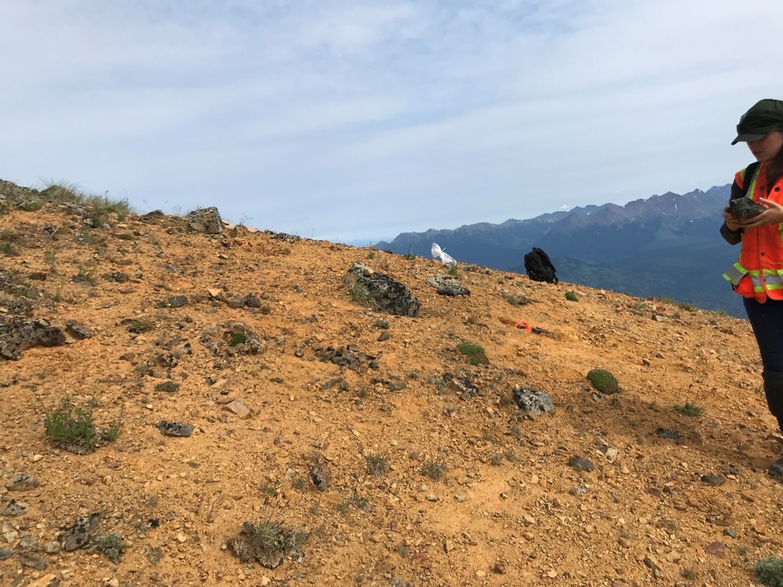
Figure 18. Outcrop of quartz tourmaline breccia zone (sample 72027).