Jaxon’s Deeper Porphyry Targets at Netalzul Mountain Confirmed by Fathom Geophysics’ Updated Comparative Model; Hazelton Property Extended to 723 km²
February 22, 2022, Vancouver, Canada - Jaxon Mining Inc. (“Jaxon” or the “Company”) (TSX.V: JAX, FSE: 0U31, OTC: JXMNF) is pleased to announce it has received the “Updated 3D porphyry footprint modeling incorporating new rock samples, Netalzul, British Columbia” report from Fathom Geophysics (the “Report”), which was commissioned as part of Jaxon’s ongoing conceptual geological modeling and porphyry target visualization and vectoring programs.
Fathom Geophysics completed the first 3D porphyry footprint modeling exercise over the Netalzul Mountain and Red Springs target areas in early 2021 (June 15, 2021 news release ). Jaxon utilized Fathom’s 2022 modeling to rank its porphyry targets at Netalzul Mountain, to create 3D visualizations of those targets, and to provide vectors pointing to the locations around the porphyry centre where there is the highest probability for intersecting volumes of porphyry copper mineralization. Additional geochemical samples taken in 2021 were included in the dataset used in the Report. The entire Netalzul dataset will be reprocessed and remodeled again by Fathom in the spring of 2022.
Fathom’s porphyry footprint modeling method works by taking an idealized model of a porphyry copper system and moving it through 3D space. The core of the targeted porphyry system is placed at every voxel in a 3D model until it fits the most logical location per the reference models. The idealized or reference model used for this work was derived from Halley et al, 2015. The geochemical model (Figure 1) Halley uses is largely derived from Yerington and includes zonation information from other significant porphyry deposits. Jaxon is using the same modeling team and approach as was used by SolGold at the Alpala epithermal porphyry discovery in Ecuador. The modeling reveals and confirms Jaxon’s view of Netalzul Mountain as a geological analog of Alpala (Figures 2, 3).
The distribution of samples used in the Report is shown in Figure 4. Many of the samples used for the previous work included only nine of the 11 elements used to generate the footprint analysis in May 2021. Those samples did not include analyses for Li and Sn. Other assays included fewer elements. An additional 38 samples were collected and analyzed in 2021. The new data have been analyzed for all 11 of the elements that the Halley model requires for the footprint modeling. The new and old data were merged into a single dataset. The new samples closed some spatial gaps in the previous dataset. The new dataset also provides more complete coverage for Sn and other elements that allow the model to approximate more accurately the actual depth of Jaxon’s targeted porphyries.
Netalzul Mountain 2022 geochemical footprint modeling highlights:
- Four porphyry targets were defined and ranked using the geochemical footprint modeling process as applied to the Netalzul rock data (Figures 5, 6). Details of the four targets are listed in Table 1.
- Targets FG-NZ-F22-Rocks-1, 2 and 3 are the same target that splits into porphyry bodies at multiple elevations from 340 m to 1030 m at depth. FG-NZ-F22-Rocks-1 is the most likely location for porphyry mineralization and should be considered the highest priority target (Figures 5, 6).
- Target FG-NZ-F22-Rocks-4 (Figures 5, 6) is a discrete deep target that is coincident with target FG-NZ-Rocks-1 from the 2021 report (June 15, 2021 news release) and is a high Zn in soil anomaly at surface (Jan 19, 2022 news release).
- The 2021 drill holes were located at the top or on the edge of the modeled deep porphyry targets (Figure 7) and are coincident with potassic and propylitic alterations seen in the drill cores, matching Jaxon’s conceptual model of the Netalzul Mt epithermal-porphyry system (Figure 8)
Table 1. Targets highlighted by the footprint modeling processing applied to the Netalzul rock data*
| Target | X | Y | RL | DEM | Depth | Ranking | Comments |
|---|---|---|---|---|---|---|---|
| FG-NZ-F22-Rocks-1 | 626820 | 6129290 | 850 | 1650 | 800 | 1 | The most likely location for a porphyry in the main target area. Close to target FG-NZ-Soils-1 from 2021 study. |
| FG-NZ-F22-Rocks-2 | 626960 | 6129270 | 620 | 1650 | 1030 | 2 | The second most likely location for a porphyry in the main target area located down and southeast of target FG-NZ-F22-Rocks-1. Close to target FG-NZ-Soils-1 from 2021 study |
| FG-NZ-F22-Rocks-3 | 626980 | 6129220 | 1320 | 1660 | 340 | 3 | The third most likely location for a porphyry in the main target area. The target is relatively shallow making it worth testing. Close to target FG-NZ-Soils-2 from 2021 study. |
| FG-NZ-F22-Rocks-4 | 626340 | 6129820 | 950 | 1520 | 570 | 4 | A separate target located northeast of the main target. It is relatively deep and lower scoring, a lower priority target. Close to target FG-NZ-Rocks-1 from 2021 study |
*Note: F22 in the target names refers to February 2022 in order to distinguish these targets from those generated previously.
New Claims Added to Hazelton Property in 2022
The Company is pleased to announce it has acquired three new claims to extend the Hazelton property to 723 km2. The three new claims (# 1093078, 1091878 and 1091901) are additions to the Rocher Deboule Mountain porphyry-epithermal project which now spans 58.9 km2, comprising eight claims and eight historical mineralization occurrences (MINFILE) (Figure 9).
Rocher Deboule Mountain project is one of seven 100% owned projects on Jaxon’s Hazelton property (Figure 10) in northwestern British Columbia, approximately 50 km north of Smithers.
New Claims and Rocher Deboule Mountain Project Highlights
- Total area of 58.9 km2 covering eight claims and eight historical mineralization occurrences or MINFILEs (Figure 9).
- Porphyry Cu-Mo mineralization has been reported on the Killarney, Jones Mt. and Hecla occurrences with assayed grades up to 0.22% Cu, 34.3 g/t Ag and trace gold (Geological Survey of Canada, Memoir 223).
- Multiple sulfide quartz vein mineralization zones in porphyritic granodiorite of the Late Cretaceous Rocher Deboule stock of the Bulkley intrusions have been reported on the Blue Lake, Lone Star, Black Pilot, and Jones occurrences with assayed grades up to 0.7 g/t Au, 1900 g/t Ag with Pb, Zn and Cu credits (Geological Survey of Canada, Memoir 223 Rev).
- The Rocher Deboule stock is one of the Late Cretaceous Bulkley intrusions and potassium/argon dating of biotite has yielded the date of 70 to 72 million years (Geological Survey of Canada, Open File 2322).
- Widespread disseminated pyrite mineralization is associated with the contact of the Late Cretaceous Rocher Deboule granodiorite stock which intrudes andesitic and dacitic flows and breccias of the Upper Cretaceous Kasalka Group.
- A large EM anomaly along the southern fringe of the Rocher Deboule stock in the MT occurrence area.
- A high percentage pyrite hole occurs on the contact zone between Late Cretaceous Rocher Deboule stock of the Bulkley intrusions and early hornfelsed sedimentary rocks.
Mr. Greg Hall of Perth, Australia, former Chief Geologist at Placer Dome and presently senior technical advisor to Jaxon, commented, “Fathom Geophysics’ 3D modeling was tested at the major copper porphyry system of Alpala Project in Ecuador. Alpala has produced some of the greatest drill hole intercepts in porphyry copper-gold exploration history, as exemplified by Hole 12 (CSD-16-012) returning 1560m grading 0.59% copper and 0.54 g/t gold including, 1044m grading 0.74% copper and 0.54 g/t gold (https://www.solgold.com.au/alpala/).”
“SolGold’s Alpala targets were analyzed using Fathom’s algorithm driven modeling procedure that, among other things, confirmed the projected/realized locations of the porphyry centres and the zoning of metals around the targeted porphyry’s centre. Fathom’s model works, in part, by calculating the distribution of porphyry indicator minerals, such as copper, molybdenum, bismuth, tellurium, selenium, arsenic, antimony, tin, and thallium present in soil and rock samples above the targeted porphyry. This distribution is compared to the distribution of the same elements observed at the Yerington, Nevada, USA porphyry copper deposit (the reference deposit) and measured as a probability of proximity.”
“Fathom’s analysis (given the constraints of the extent of datasets provided by the companies) suggests the probability of a major copper porphyry discovery area at the Netalzul Mountain deposit is comparable to the Alpala deposit. The surface anomalies at both projects are of similar size. It is my view that Netalzul presents as compelling a porphyry target as Alpala and, in time, there should be other porphyry targets with similar scope and scale that will be confirmed at Hazelton.”
Mr. John King Burns, CEO and Chairman of Jaxon, commented,“The February 2020 report from Fathom Geophysics formally rings the Netalzul Mountain porphyry test starting bell. We are excited to use Scott Halley’s geochemically-driven mineral deposit “porphyry” exploration model and will now execute our modeling driven, integrated, multidisciplinary, exploration processes at Netalzul to focus on improving our vectoring parameters to better define the location and geometry of the Netalzul Mountain porphyry target. All Netalzul data will be reprocessed in the winter of 2022 and the models will be re-run and then used to inform the design of the drill program. In the summer of 2022, Jaxon plans to drill test the shells around the centre of the porphyry system at various depths. Netalzul is the first of Jaxon’s seven porphyry-epithermal system targets at Hazelton. Jaxon is in discussions with a number of technically qualified, potential drilling and development partners about participating in drilling and other joint ventures.”
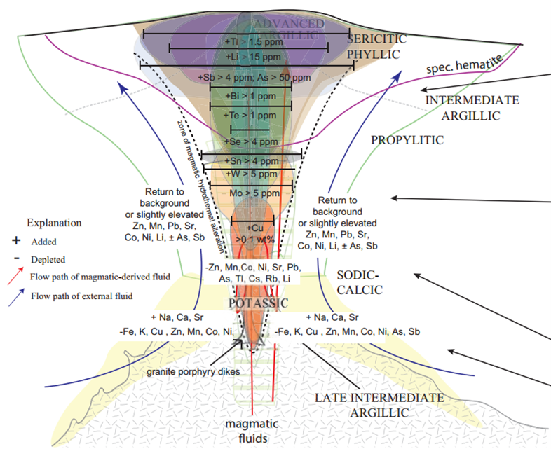
Figure 1. The interpreted geochemical zonation around porphyry copper systems based on Ann-Mason as well as other porphyry systems from Halley et al, 2015.

Figure 2. Alpala and Netalzul Mountain deposit anomaly footprint comparisons.
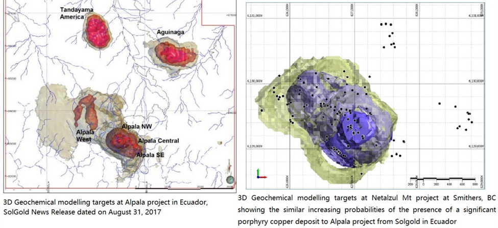
Figure 3. 3D geochemical porphyry footprint modeling target comparison between the Alpala deposit in Ecuador and Jaxon's Netalzul Mountain deposit in BC, Canada.
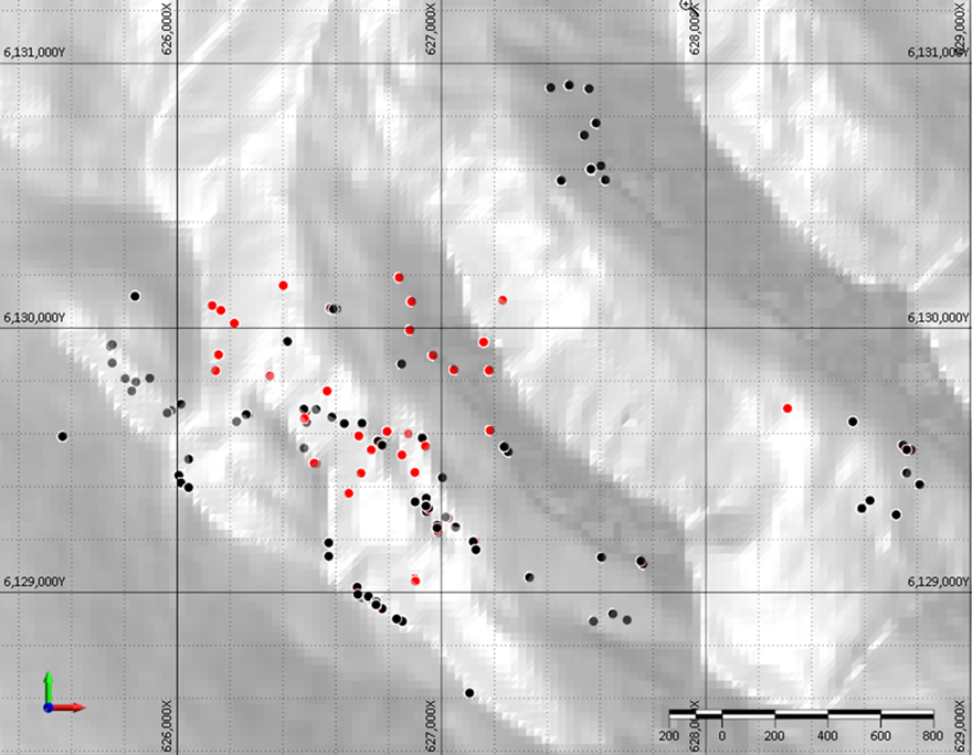
Figure 4. Rock sample locations at the Netalzul project area showing two generations of samples. Samples used in 2021 in black and new samples in red.
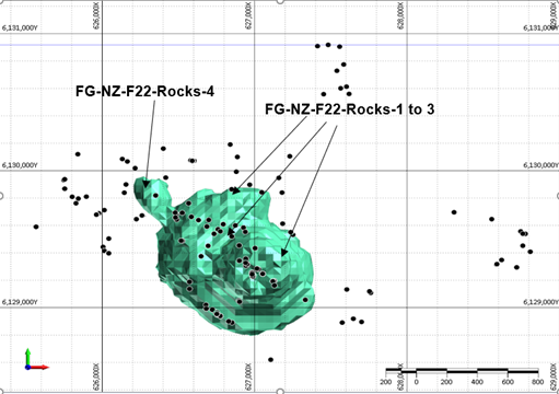
Figure 5. Targeting results plan view shows 0.85 isosurface of the results for the rock samples using the Halley model. The results are masked to show better constraint. FG-NZ-Rock1 is a relatively vertically extensive target and scores very highly.

Figure 6. Targeting results section view shows a cross section through the unmasked soil processing results. The section is from 625800E 6130315N on the left to 627660E 6128520N on the right. The main target area is split into three zones with FG-NZ-F22-Rocks-3 being shallow and FG-NZ-F22-Rocks-1 and FG-NZ-Rocks-2 being deeper.
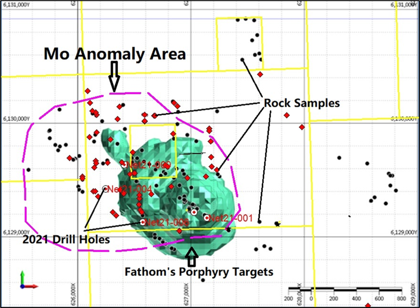
Figure 7. 2021 drill hole location and Fathom's geochemistry footprint modeling porphyry targets.

Figure 8. Conceptual model of epithermal-porphyry system at Netalzul Mountain.
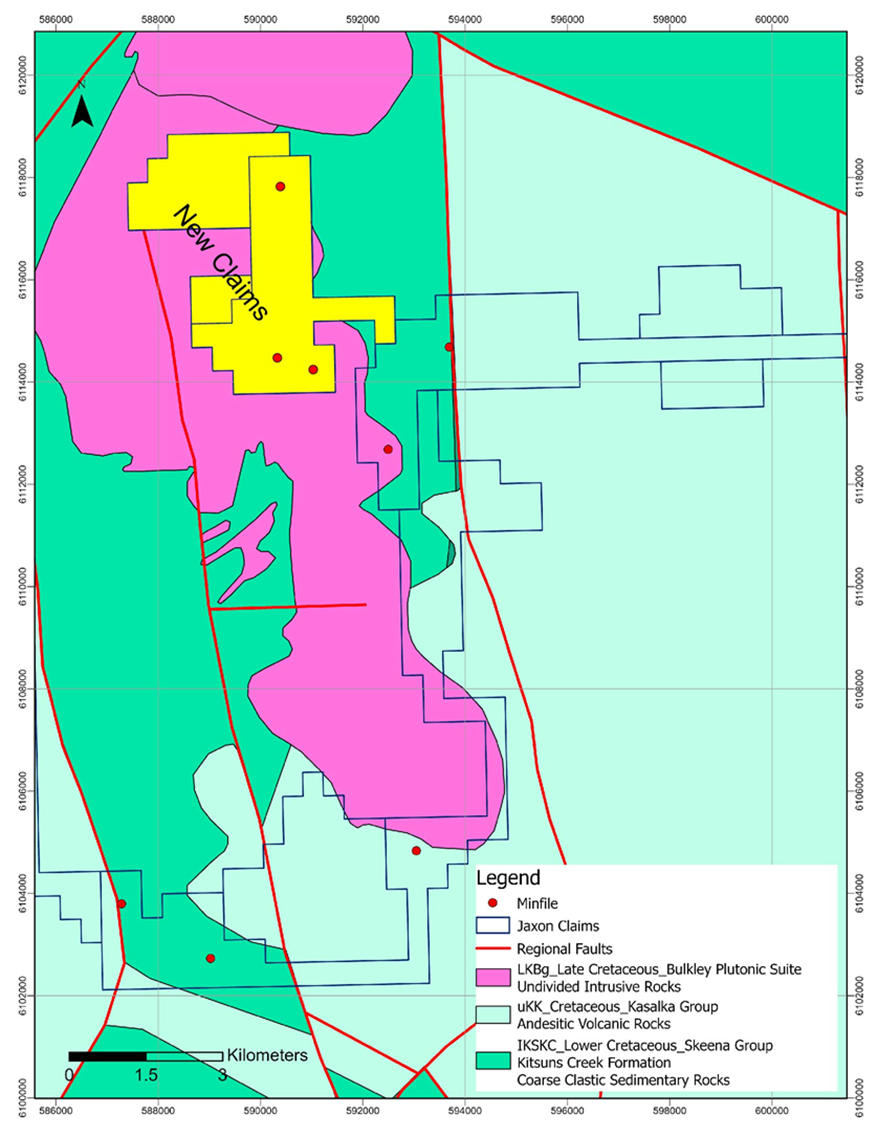
Figure 9. Claims and geology map at Rocher Deboule Mountain project.
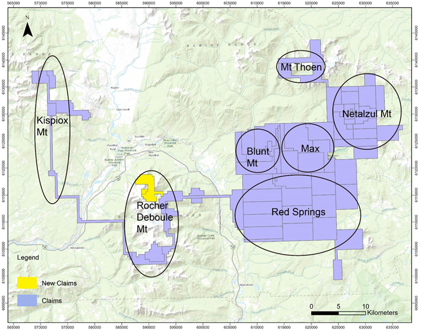
Figure 10. Claims map of seven projects at Hazelton property.
About Fathom Geophysics
Fathom Geophysics provides geophysical and geoscience data processing and targeting services to the minerals and petroleum exploration industries, from the regional scale through to the near-mine deposit scale. Among the data types we work on are potential field data (gravity and magnetics), electrical data (induced polarization and electromagnetics), topographic data, seismic data, geochemical data, precipitation, and lake-level time-lapse environmental data, and remotely sensed (satellite) data such as Landsat and ASTER.
Fathom Geophysics offers automated data processing, automated exploration targeting, and the ability to tailor-make data processing applications. Fathom Geophysics’ automated processing is augmented by expert geoscience knowledge drawn from in-house staff and from details relayed to us by the project client. Fathom Geophysics also offers standard geophysical data filtering, manual geological interpretations, and a range of other exploration campaign-related services, such as arranging surveys and looking after survey-data quality control.
About Footprint Modeling Method
The porphyry footprint modeling method works by taking an idealized model of a porphyry copper system and moving it through 3D space. The core of the system is placed at every voxel in a 3D model. At every voxel, the fit between observed data and the idealized model are examined and a score is assigned with a value between 0 and 1.
A value of 1 indicates that the geochemical data perfectly match the idealized porphyry model and there is a high likelihood of a porphyry core at the pixel location. A value of 0 indicates that the data do not match a porphyry system at all and there is a low likelihood of a porphyry core at the pixel location.
The idealized model used for this work has been derived from Halley et al (2015). The geochemical model (Figure 1) is largely derived from Yerington but does include zonation information from other significant porphyry deposits.
Qualified Person
Yingting (Tony) Guo, P.Geo., President and Chief Geologist of Jaxon Mining Inc., a Qualified Person as defined by National Instrument 43-101, has reviewed and prepared the scientific and technical information and verified the data supporting such scientific and technical information contained in this news release.
About Jaxon Mining Inc.
Rich in large-scale geological targets/assets, Jaxon has seven porphyry system targets on its 100% controlled Hazelton property, an interconnected network of concessions spanning 700 km2 in the Skeena Arch in northwest British Columbia, Canada. The Skeena Arch is an exceptionally orogenic and metallogenic setting, geochronologically suitable to host preserved porphyries.
Jaxon pursues the discoveries of deeper, under cover, commercial scale and grade Cu, Au, Ag, polymetallic porphyry epithermal systems associated with distal mineralized, propylitically altered zones nearer to surface. Jaxon's team is made up of experienced model-driven explorationists. Geochemical, geophysical and structural data is collected and integrated to generate 3D models to assist in the visualization and projection of the location of targeted porphyry systems.
Netalzul Mt is Jaxon's most advanced target, the priority of seven identified porphyry epithermal system targets at Hazelton. Red Springs is the second target being prepared for drill testing. The five other targets are in various advancing stages of exploration.
ON BEHALF OF THE BOARD OF DIRECTORS
JAXON MINING INC.
“John King Burns”
John King Burns, Chairman
For more information please contact:
Investor Relations
Kaye Wynn Consulting
T: 604-558-2630
TF: 1-888-280-8128
E: info@kayewynn.com
Freeform Communications
T: 604-243-0499
E: enquiries@freeform.com
Corporate
T: 604-424-4488
E: info@jaxonmining.com
This news release may contain forward-looking information, which is not comprised of historical facts. Forward-looking information involves risks, uncertainties and other factors that could cause actual events, results, performance, prospects and opportunities to differ materially from those expressed or implied by such forward-looking information. Forward-looking information in this news release may include, but is not limited to, the Company's objectives, goals or future plans. Factors that could cause actual results to differ materially from such forward-looking information include, but are not limited to, those risks set out in the Company's public documents filed on SEDAR. Although the Company believes that the assumptions and factors used in preparing the forward-looking information in this news release are reasonable, undue reliance should not be placed on such information, which only applies as of the date of this news release, and no assurance can be given that such events will occur in the disclosed time frames, or at all. The Company disclaims any intention or obligation to update or revise any forward-looking information, whether as a result of new information, future events or otherwise, other than as required by law. Neither TSX Venture exchange nor its Regulations Services Provider (as that term is defined in the policies of the TSX Venture Exchange) accepts responsibility for the adequacy or accuracy of this release.